


 KINGSTON, JAMAICA:--- A rapidly intensifying storm, Hurricane Melissa, has become a devastating Category 5 hurricane and is bearing down on Jamaica with the potential to be one of the worst disasters in the country’s recorded history.
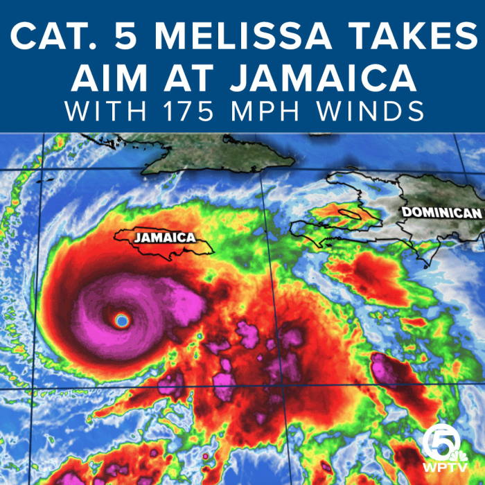
Storm status & trajectory
According to the National Hurricane Center (NHC), Melissa is currently producing sustained winds of up to 175 mph (282 km/h). It is moving slowly west-northwest at roughly 3-5 mph, giving the storm more time to inflict damage.
The storm's center is located southwest of Jamaica and is forecast to move across the island late Monday into early Tuesday, with its worst impacts arriving through Monday night and Tuesday.
Why is the danger so high
- Slow movement: The slow pace means sustained rainfall and winds over the same areas, increasing flooding, landslide and structural damage risks.
- Extreme intensity: A Category 5 is rare and especially dangerous. Jamaica has never experienced a direct landfall from a storm of this intensity.
- Heavy rainfall forecasts: Up to 40 inches (≈1 m) of rain are possible in higher terrain, which could trigger major flooding and landslides.
- Storm surge and wind threats: Coastal areas are at risk of life-threatening storm surge and destructive winds that can damage infrastructure, homes and power systems.
Preparations & Government actions
The Government of Jamaica has declared a state of emergency and ordered mandatory evacuations for particularly vulnerable areas, such as coastal communities and flood-prone zones.
More than 800 shelters have been opened nationwide, and airports have been closed in advance of the storm.
Prime Minister Andrew Holness warned residents: “This is not a drill … take this storm seriously.”
What is expected & what could go wrong
- Wind damage: Buildings, especially older or poorly constructed ones, face a high risk of roof damage, wall collapse, and widespread power outages.
- Flooding & landslides: With forecast rain and Jamaica’s mountainous terrain, landslides and flash floods are very likely, possibly isolating communities.
- Coastal destruction: Storm surge, large waves, and coastal inundation will severely affect southern parishes, fishing villages, and infrastructure near sea level.
- Extended recovery: Even after the eye passes, dangerous conditions will persist. Some remote areas may remain cut off and without services for days or weeks.
Advice to residents & visitors
- Evacuate now if you are in a low-lying, coastal, or flood-prone area. Do not wait.
- Seek shelter in a strong building, away from flood zones, and bring essentials (medications, documents, supplies).
- Stay informed via ODPEM (Office of Disaster Preparedness & Emergency Management), the Meteorological Service of Jamaica, and official advisories.
- Avoid risky behaviour: Don’t drive through flooded roads or stay in severely exposed areas.
- After the storm: Be cautious about downed power lines, contaminated water, and unstable structures.