~France completes parliamentary approval of historic border treaty; Dutch Kingdom still awaits final ratification.~
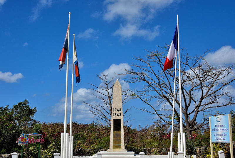 PHILIPSBURG/MARIGOT:--- Nearly four centuries after French and Dutch settlers agreed to divide the island of St. Martin, one of the oldest unresolved international boundaries in the Caribbean is on the verge of finally being settled.
On Thursday, July 16, 2026, the French National Assembly adopted the bill authorizing the Agreement between the French Republic and the Kingdom of the Netherlands establishing the international boundary between Saint-Martin and Sint Maarten to be approved. The vote marks the completion of France's parliamentary approval process for a treaty that finally defines, in legal and geographical terms, where French territory ends and Dutch territory begins.
The agreement, however, is not yet in force. Before it can take legal effect, the Kingdom of the Netherlands must complete its own parliamentary approval process through Kingdom Bill 36956 (R2220), which is still before the Dutch Parliament.
When that process is completed and both governments exchange diplomatic notifications confirming that their constitutional procedures have been fulfilled, history will be made.
For the first time since 1648, the entire border separating the French Republic and the Kingdom of the Netherlands on the island will have a legally recognized and internationally ratified definition.
A Border Created in 1648—But Never Completely Defined
The story begins almost 378 years ago.
On March 23, 1648, representatives of France and the Dutch Republic signed what became known as the Treaty of Concordia.
The agreement divided the island between the two colonial powers after Spain abandoned its occupation.
The treaty established that both nations would peacefully coexist and that residents would enjoy freedom of movement between both territories.
But while the treaty determined which portions of the island belonged to each nation, it never established an exact border using modern surveying methods or geographical coordinates.
Instead, the border relied largely on natural landmarks, historical descriptions and mutual understanding.
For centuries, this informal arrangement functioned reasonably well.
People lived, worked, traded and crossed freely between both sides.
However, governments increasingly encountered legal uncertainty whenever questions arose involving:
- land ownership,
- coastal development,
- Oyster Pond,
- maritime jurisdiction,
- environmental protection,
- policing,
- infrastructure,
- disaster response,
- public utilities,
- and future investment projects.
The absence of an internationally defined boundary became more problematic as the island developed and technology made precise surveying possible.
Decades of Negotiations
According to the French parliamentary reports, discussions on formally defining the border have taken place for decades.
Experts from both governments conducted surveys, exchanged technical information and negotiated solutions to historically disputed sections.
The most difficult issues involved Oyster Pond (Étang aux Huîtres) and adjoining coastal waters.
Unlike inland areas where the border was generally accepted, Oyster Pond presented legal uncertainty over exactly where French jurisdiction ended and Dutch jurisdiction began.
The uncertainty affected navigation, environmental management, policing, permitting, development and emergency response.
Negotiations continued for more than twenty years before both governments finally reached agreement.
The Historic Signing
On May 26, 2023, representatives of both countries gathered at Belle Plaine/Belvédère to sign the treaty.
Representing the Kingdom of the Netherlands was then Prime Minister of Sint Maarten Silveria Jacobs.
Representing France was then Minister of the Interior and Overseas Territories Gérald Darmanin.
Although signed in 2023, the treaty could not become law immediately.
Under both French and Dutch constitutional systems, international treaties affecting national territory require parliamentary approval before they can enter into force.
France Moves First
France formally began the ratification process on February 25, 2026, when the government submitted Bill No. 437 to the French Senate.
On that same day, the French Government invoked the accelerated legislative procedure, recognizing the importance of the treaty.
The Senate Committee on Foreign Affairs, Defense and Armed Forces examined the legislation and issued its report on April 8, 2026.
One week later, on April 15, the French Senate adopted the bill.
The legislation was immediately forwarded to the National Assembly on April 16, where it became Bill No. 2688.
The National Assembly's Foreign Affairs Committee studied the treaty in detail before filing Report No. 2996 on July 1.
Finally, on Thursday, July 16, 2026, the National Assembly approved the legislation without amendment under France's simplified examination procedure.
The adopted legislation became Text Adopted No. 333.
France had completed its parliamentary responsibility.
The Dutch Kingdom Still has Work to Do
Unlike France, the Kingdom of the Netherlands has not yet finalized its approval.
The Dutch Government introduced Kingdom Bill 36956 (R2220) on May 28, 2026.
The legislation is considered a Kingdom Act because the treaty concerns one of the autonomous countries within the Kingdom—Sint Maarten.
Although foreign affairs remain a Kingdom responsibility, territorial agreements affecting Sint Maarten require approval through the Kingdom legislative process.
The bill was referred to the Standing Committee on Foreign Affairs on June 3.
Committee members submitted written questions on June 24.
As of July 16, however, parliamentary debate and voting had not yet taken place.
Only after the Dutch Parliament completes its work can the Kingdom proceed toward ratification.
Why Oyster Pond Mattered So Much
One of the principal reasons for negotiating the treaty was Oyster Pond.
For generations, there were differing interpretations regarding where the international border passed through the lagoon.
This uncertainty affected numerous governmental responsibilities.
Questions arose over which government had authority to:
- issue permits,
- regulate marinas,
- investigate environmental violations,
- remove wrecks,
- enforce laws,
- supervise construction,
- undertake dredging,
- respond to emergencies.
Following Hurricane Irma in 2017, those questions became increasingly urgent.
Massive destruction required reconstruction on both sides of the island.
Government agencies needed legal certainty regarding jurisdiction before undertaking certain recovery projects.
The treaty finally establishes that certainty through precise coordinates contained in its annexes.
Not Just a Line on a Map
The treaty is far more than a simple border agreement.
It provides a comprehensive legal framework for managing the international boundary.
Among other matters, it addresses:
- the precise land boundary,
- maritime delimitation,
- internal waters,
- coastal waters,
- official maps,
- technical coordinates,
- maintenance of boundary markers,
- cooperation between authorities,
- future surveys,
- procedures if markers are damaged,
- legal certainty for public administration.
Instead of relying upon historical descriptions dating back centuries, both governments will now use modern geodetic coordinates.
What Does Not Change
Despite dramatic headlines suggesting that France and the Netherlands are "getting a new border," residents should not expect dramatic changes in daily life.
There will be:
- no wall,
- no fence,
- no customs barrier,
- no passport checkpoints,
- no interruption of free movement.
The island's open character remains unchanged.
Residents will continue crossing between both sides just as they have for generations.
The treaty determines legal jurisdiction—not the movement of people.
What Does Change
The agreement significantly strengthens legal certainty.
Government departments will know exactly where their authority begins and ends.
This affects:
- police investigations,
- judicial cooperation,
- environmental enforcement,
- land registration,
- infrastructure projects,
- marina regulation,
- coastal development,
- disaster response,
- public works,
- future investments.
Developers, engineers and surveyors will now work from officially recognized international coordinates instead of historical interpretations.
Why This is Important for St. Maarten
For Sint Maarten, the treaty represents more than an international formality.
It provides certainty for future generations.
Government decisions concerning Oyster Pond, coastal development, maritime management and environmental protection will rest upon internationally recognized boundaries.
Cross-border cooperation between French and Dutch authorities will also become easier because jurisdictional questions will be substantially reduced.
The agreement provides both governments with a common legal framework for resolving future issues rather than relying upon historical custom.
A Treaty Built for the Future
The agreement also establishes mechanisms for maintaining the boundary over time.
Modern surveying techniques make it possible to accurately relocate boundary points should markers disappear or be damaged.
Technical annexes accompany the treaty containing official maps and geographic coordinates.
Those annexes become part of the international agreement itself.
Still One Final Step
Although France has completed parliamentary approval, the treaty is not yet operational.
The Kingdom of the Netherlands must still complete its legislative process.
After parliamentary approval in both countries, the governments must exchange diplomatic notifications confirming that each has fulfilled its constitutional requirements.
Only then will the agreement formally enter into force.
The End of A 377-Year Legal Uncertainty
For nearly four centuries, the island has lived with an internationally recognized political division that was never completely defined in legal or geographical terms.
Generations accepted the border largely because tradition and cooperation prevailed.
But modern governance requires precision.
Today, satellite surveying, international law, environmental management, disaster planning and coastal development demand exact boundaries—not historical approximations.
The treaty approved by France this week represents the culmination of years of negotiations, technical surveys and diplomatic cooperation between two neighboring governments that share one of the most unique islands in the world.
Once the Dutch Kingdom completes its own parliamentary approval, the border first envisioned under the Treaty of Concordia in 1648 will finally become a fully defined international frontier.
It is a historic milestone not because it changes how the people of the island live, but because it brings legal certainty to one of the Caribbean's oldest shared frontiers.
For St. Maarten and Saint-Martin, it closes a chapter that remained unfinished for 377 years and opens a new era in which the island's shared history is matched by a clearly defined international boundary recognized by both nations.